
LAND LESSONS- What are Metes and Bounds?
A type of survey used in England and many of its colonies, it uses the physical features of the local geography, along with directions and distances, to define and describe the boundaries of a parcel of land. The boundaries are described in a running prose style, working around the parcel in sequence, from a point of beginning, returning to the same point. It may include references to other adjoining parcels (and their owners), and it, in turn, could also be referred to in later surveys. At the time the description is compiled, it may have been marked on the ground with permanent monuments placed where there were no suitable natural monuments.
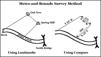
Metes refers to a boundary defined by the measurement of each straight run, specified by a distance between the terminal points, and an orientation or direction. A direction may be a simple compass bearing or a precise orientation determined by accurate survey methods.
Bounds (Abuttals and boundaries) refer to a more general boundary description, such as along a certain watercourse, a stone wall, an adjoining public roadway, or an existing building. The system is often used to define larger pieces of property (e.g., farms) and political subdivisions (e.g., town boundaries) where precise definition is not required or would be far too expensive, or previously designated boundaries can be incorporated into the description.
Although there were earlier recording provisions in Virginia and elsewhere, in 1640, Massachusetts passed the recording law that would become the template for most colonial recording acts. It required settlers to record all transfers “[f]or avoiding all fraudulent conveyances, & that every man may know what estate or interest other men may have in any houses, lands, or other hereditaments they are to deale in.” One did this by describing the land being conveyed. Since communities were small and tight knit, using local landmarks as references that were known by most was common. Describing a tree where someone was hung, a pile of stones, an area of land where some local event occurred, or a wall or other barrier easily incorporated itself into the narrative description of metes and bounds as reference points