
LAND LESSONS- What is the Baltimore County URDL?
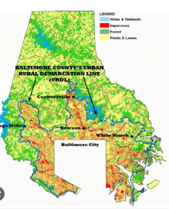
The Urban-Rural Demarcation Line (URDL) divides the county into 2 categories, “urban” and “rural”. This Urban Rural Demarcation Line shows where growth is encouraged and where land should remain farmland.
After World War II, millions of young veterans returned to America anxious to marry and start their families. In Baltimore County in the late 1940s, a building boom was underway as farmland near the Baltimore City border was bought by developers and quickly transformed into subdivisions. Neighborhoods in Linthicum, Catonsville, Pikesville, Towson, Parkville, Essex, and Dundalk were soon constructed by local independent homebuilders such as Ralph DeChairo, Henry Knott, Carl & Ed Julio, Joseph Meyerhoff and James Keelty.
In 1949, there was talk about building a road that would connect arterial roads such as Belair, Harford, York, Frederick, Park Heights Avenue linking these communities. Today we know this road as the Baltimore Beltway (or 695). It was started as a county road project, but in 1953 the state took over the design and construction. The beltway was opened in stages from 1955-1962 with the final stage across the Key Bridge opening in 1973.
Building a road that could quickly bring folks from the city out to the farthest areas of Baltimore County’s farm country concerned many of the wealthy landowners living in “The Valleys” namely the Greenspring, Worthington, Caves, Worthington-Belfast, Stringtown and Western Run.
In 1961, residents from these areas formed The Valleys Planning Council to protect their land from development. They hired the planning firm Wallace, McHarg, Roberts and Todd to analyze and present a plan that would allow for growth while still preserving most of pristine farmland.
A plan was presented to County Executive Spiro Agnew to allow limited development on the ridges but very limited development on the valley floor. It was further suggested that no public utilities should be brought out to the Valleys, nor should existing roads be straightened or widen. Agnew rejected the idea worried that other communities would create their own plans for growth.
Ultimately, in 1967, the Planning Board established the URDL limiting growth and concentrating all the development to areas that would be served by public utilities and road infrastructure. A line showing areas of public service was created that wrapped like a belt around the county. Areas of growth are inside the belt and carry a zoned Density Residential or various commercial or industrial classifications, while rural areas are labeled as Resource Conservation.
Today, 2/3s of Baltimore County remains rural and 90% of its population lives on just the 1/3 of land that has been zoned for development.